ByJohn A
Rain-Ready Development Planning in Northern Virginia, Virginia
Northern Virginia development projects must account for more than building footprints, parking counts, and utility connections. Rainfall moves quickly across roofs, drive aisles, sidewalks, and compacted soil, particularly on sites with rolling terrain or limited open space.
Understanding stormwater regulations in Northern Virginia early helps owners, builders, and design teams make site decisions that support drainage, water quality, erosion control, and a more orderly review process.
Thoughtful stormwater planning is not simply about placing a pond or drain at the edge of a property. It is about understanding how water enters, crosses, slows down, infiltrates, and safely leaves the site.
When these questions are addressed before grading and layout decisions are fixed, projects are better positioned to protect neighboring properties and the local streams that ultimately connect to the Potomac River and Chesapeake Bay watershed.
Why Rain-Ready Planning Matters?
Hard surfaces generally shed rain faster than wooded or planted areas. A small commercial building, for example, may create a drainage problem if its parking area directs runoff toward an adjoining lot or an already stressed curb inlet.
Planning for rainfall at the start can reduce the risk of erosion, avoid late design changes, and create clearer expectations for construction and maintenance.
Start With The Site
Before selecting a final building location, review what the land is already doing. Existing slopes, tree cover, soils, swales, wetlands, streams, utility corridors, and off-site drainage routes can all influence a workable layout. A design that respects natural drainage patterns often requires fewer corrective measures after construction begins.
Key Site Questions
- Where does water flow during ordinary rainfall and larger storms?
- Which low areas already collect water or support vegetation?
- Are steep slopes, shallow soils, or erosion-prone areas present?
- Could grading block an established drainage path?
- Where will stockpiles, equipment, and temporary construction access be located?
Map Water Before Drawing Plans
Good planning combines survey information with field observations. Topography, existing inlets and pipes, soil conditions, flood-risk screening, impervious cover, and nearby public drainage facilities should be evaluated together. Digital mapping is useful, but it may not reveal a shallow swale, a blocked pipe, or a drainage issue that appears only after a storm.
Reduce Runoff At The Source
A practical goal is to keep rain close to where it falls whenever site conditions allow. Rather than directing every drop toward one large facility, a plan can distribute runoff reduction across the property. This may include preserving healthy mature trees, limiting unnecessary pavement, using compact building layouts, routing roof runoff to planted areas, and dividing large paved areas into smaller drainage zones.
Permeable surfaces, planted treatment areas, and infiltration practices can be valuable tools, but they are not automatic solutions. Each requires appropriate soil conditions, reliable overflow routing, compatible traffic loads, and realistic maintenance expectations.
Choose The Right Stormwater Features
No single stormwater feature works for every Northern Virginia site. The right approach depends on available space, slopes, soils, groundwater conditions, drainage area, proposed land use, and the ability to maintain the finished system.
- Rain gardens or bioretention areas: Useful for treating runoff in planted areas, provided they have suitable media, drainage, and overflow paths.
- Vegetated swales: Can slow and convey runoff along site edges, but require careful grading and accessible maintenance areas.
- Infiltration practices: Allow water to soak into the ground where testing supports their use and groundwater conditions are appropriate.
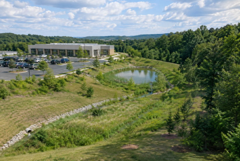
- Detention facilities: Temporarily store runoff and need dependable outlets, safe access, and a clear long-term maintenance plan.
- Permeable pavement: May reduce runoff in selected parking or pedestrian areas, but sediment control and periodic cleaning are important.
Build Compliance Into The Design
Regulatory coordination works best when it is part of the design, not a final paperwork task. Confirm the reviewing authority, identify the type and extent of land disturbance, coordinate drainage with utilities and landscaping, and allow time for review comments and revisions. Construction stormwater permits, local land-disturbance approvals, and erosion and sediment control requirements may involve separate processes.
Plan For The Construction Phase
Even a well-designed permanent system can be undermined if construction exposes large areas of soil or changes temporary drainage routes. Install erosion controls before major earthwork, protect storm drain inlets, separate clean water from disturbed areas where feasible, and stabilize completed portions of the site as work progresses. After significant rain, inspect the controls and adjust them to actual field conditions.
Prepare For Long-Term Maintenance
Stormwater facilities are working systems, not set-and-forget landscape features. Sediment, leaves, trash, invasive growth, damaged outlets, and clogged surfaces can limit performance.
In Fairfax County, for example, private facility owners remain responsible for maintaining their systems, while the county conducts inspections to help confirm facilities function according to approved designs.
The county’s maintenance and inspection guidance illustrates why ownership, access, inspections, and recordkeeping should be resolved before construction is complete.
Maintenance Plan Items
- Name the owner responsible for each feature.
- Provide safe access for inspections and repairs.
- Set inspection intervals and document findings.
- Identify signs that sediment removal, planting work, or structural repairs are needed.
- Keep approved plans, maintenance records, and field notes together.
Common Planning Mistakes To Avoid
- Studying drainage after the building and parking layout is fixed.
- Relying only on online mapping without a field review.
- Concentrating all runoff at one undersized location.
- Ignoring access needed for maintenance equipment.
- Separating grading, landscaping, and utility planning.
- Forgetting temporary drainage during construction.
- Selecting a practice that does not fit local soil conditions.
- Failing to provide a safe overflow route for larger storms.
A Simple Project Checklist
- Review natural drainage patterns before finalizing the layout.
- Identify streams, wetlands, trees, steep slopes, and low areas.
- Compare existing and proposed impervious surfaces.
- Evaluate several runoff-reduction options.
- Coordinate stormwater features with buildings, utilities, and access routes.
- Confirm applicable review, permit, and inspection requirements.
- Plan temporary erosion and drainage controls.
- Assign long-term maintenance responsibilities.
Conclusion
Rain-ready development in Northern Virginia begins with careful site observation and coordinated design. When drainage, grading, landscaping, construction controls, compliance, and maintenance are considered together, owners and project teams can make stronger decisions before water becomes a costly problem.